


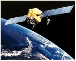
What is GPS?
GPS or Global Positioning System is a
satellite navigation system that furnishes location and time information
in all climate conditions to the user. GPS is used for navigation in
planes, ships, cars and trucks also. The system gives critical abilities
to military and civilian users around the globe. GPS provides
continuous real time, 3-dimensional positioning, navigation and timing
worldwide.
How does GPS System Work?
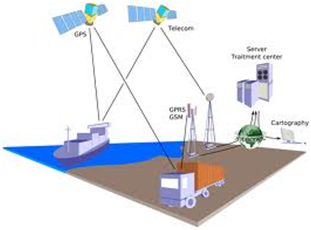
The GPS system consists of three segments:
1) The space segment: the GPS satellites
2) The control system, operated by the U.S. military,
3) The user segment, which includes both military and civilian users and their GPS equipment.
Space Segment:
The space segment is the number of
satellites in the constellation. It comprises of 29 satellites circling
the earth every 12 hours at 12,000 miles in altitude. The function of
the space segment is utilized to route/navigation signals and to store
and retransmit the route/navigation message sent by the control segment.
These transmissions are controlled by highly stable atomic clocks on
the satellites. The GPS Space Segment is formed by a satellite
constellation with enough satellites to ensure that the users will have,
at least, 4 simultaneous satellites in view from any point at the Earth
surface at any time.

Control Segment:
The control segment comprises of a
master control station and five monitor stations outfitted with atomic
clocks that are spread around the globe. The five monitor stations
monitor the GPS satellite signals and then send that qualified
information to the master control station where abnormalities are
revised and sent back to the GPS satellites through ground antennas.
Control segment also referred as monitor station.
control segment
User Segment:
The user segment comprises of the GPS
receiver, which receives the signals from the GPS satellites and
determine how far away it is from each satellite. Mainly this segment is
used for the U.S military, missile guidance systems, civilian
applications for GPS in almost every field. Most of the civilian uses
this from survey to transportation to natural resources and from there
to agriculture purpose and mapping too.
User segment
How GPS Determines a Position:
The working/operation of Global
positioning system is based on the ‘trilateration’ mathematical
principle. The position is determined from the distance measurements to
satellites. From the figure, the four satellites are used to determine
the position of the receiver on the earth. The target location is
confirmed by the 4th satellite. And three satellites are used
to trace the location place. A fourth satellite is used to confirm the
target location of each of those space vehicles. Global positioning
system consists of satellite, control station and monitor station and
receiver. The GPS receiver takes the information from the satellite and
uses the method of triangulation to determine a user’s exact position.

GPS is used on some incidents in several ways, such as:
- To determine position locations; for example, you need to radio a helicopter pilot the coordinates of your position location so the pilot can pick you up.
- To navigate from one location to another; for example, you need to travel from a lookout to the fire perimeter.
- To create digitized maps; for example, you are assigned to plot the fire perimeter and hot spots.
- To determine distance between two different points.
3 Advantages of GPS:
- GPS satellite based navigation system is an important tool for military, civil and commercial users
- Vehicle tracking systems GPS-based navigation systems can provide us with turn by turn directions
- Very high speed
2 Disadvantages of GPS:
- GPS satellite signals are too weak when compared to phone signals, so it doesn’t work as well indoors, underwater, under trees, etc.
- The highest accuracy requires line-of-sight from the receiver to the satellite, this is why GPS doesn’t work very well in an urban environment.
Using a GPS Receiver:
There are several different models and types of GPS receivers. While working with a GPS receiver it is important to have :
- A compass and a map.
- A downloaded GPS cable.
- Some extra batteries.
- Knowledge about the memory capacity of the GPS receiver to prevent loss of data, decrease in accuracy of data, or other problems.
- An external antenna whenever possible, especially under tree canopy, in canyons, or while driving.
- A set up GPS receiver according to incident or agency standard regulation; coordinate system.
- Notes that describe what you are saving in the receiver.
GPS Error
There are many sources of possible
errors that will degrade the accuracy of positions computed by a GPS
receiver. The travel time taken by the GPS satellite signals can be
changed by atmospheric effects; when a GPS signal passes through the
ionosphere and troposphere it is refracted, causing the speed of the
signal to be different from the speed of a GPS signal in space. Another
source of error is noise, or distortion of the signal which causes
electrical interference or errors inherent in the GPS receiver itself.
The information about satellite orbits will also cause errors in
determining the positions, because the satellites are not really where
the GPS receiver “thought” based on the information it received when it
determine the positions. Small variations in the atomic clocks on board
the satellites can translate to large position errors; a clock error of
1 nanosecond translates to 1 foot or .3 meters user error on the
ground. A multipath effect occurs when signals transmitted from the
satellites bounce off a reflective surface before getting to the
receiver antenna. During this process, the receiver gets the signal in
straight line path as well as delayed path (multiple paths). The effect
is similar to a ghost or double image on a TV set.
Geometric Dilution of Precision (GDOP)
Satellite geometry can also affect the
accuracy of GPS positioning. This effect is refers as Geometric Dilution
of Precision (GDOP). Which is refers to where the satellites are in
related to one another, and is a measure of the quality of the satellite
configuration. It can be able to modify other GPS errors. Most GPS
receivers select the satellite constellation that will give the least
uncertainty, the best satellite geometry.
GPS receivers usually report the quality
of satellite geometry in terms of Position Dilution of Precision, or
PDOP. PDOP are of two types, horizontal (HDOP) and vertical (VDOP)
measurements (latitude, longitude and altitude). We can check the
quality of the satellite positioning the receiver is currently available
by the PDOP value. A low DOP indicates a higher probability of
accuracy, and a high DOP indicates a lower probability of accuracy.
Another term of PDOP is TDOP (Time Dilution of Precision). TDOP refers
to satellite clock offset. On a GPS receiver can set a parameter known
as the PDOP mask. This will cause the receiver to ignore satellite
configurations that have a PDOP higher than the limit specified.
Selective Availability (SA):
Selective Availability occurs when the
DOD intentionally degraded; the accuracy of GPS signals is introducing
artificial clock and ephemeris errors. During the implementation of SA,
it was the largest component of GPS error, causing error of up to 100
meters. SA is a component of the Standard Positioning Service (SPS).


No comments:
Post a Comment